Click button below to view 360° VR interactive panorama
SD Standard definition suitable for users with slow internet connections or mobile devices or HD High definition suitable for users with fast internet connections
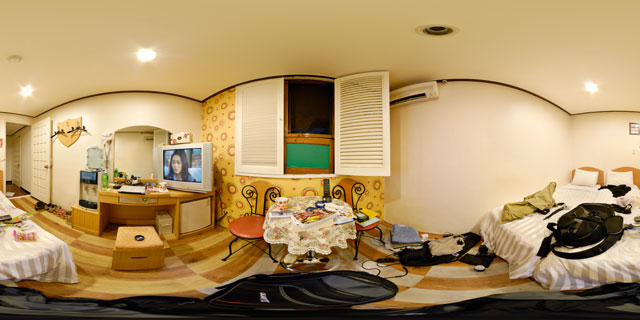
360° VR panorama of a twin bed hotel room at the Hotel Biz Myeong-dong (호텔 비즈 명동), in Seoul, South Korea. The Hotel is located in Euljiro 3(sam)-ga, and is only a few minutes walk from the nearest subway station. Although the rooms are fairly basic, the hotel is popular due to its low costs, central location, and multi lingual staff.
Click button below to view 360° VR interactive panorama
SD Standard definition suitable for users with slow internet connections or mobile devices or HD High definition suitable for users with fast internet connections
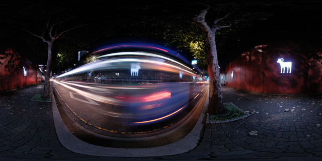
360° VR panorama of a bus passing by the 101 Pine Avenue (101파인애비뉴건) construction site on Euljiro 2(il)-ga, Jung-gu, Seoul, South Korea. The 101 Pine Avenue development consists of 2 buildings, and is proposed to be decorated with 101 works of art and pine trees planted around the buildings. The outside of the boards surrounding the development are decorated with large silhouettes of various animals, which light up at night.
Click button below to view 360° VR interactive panorama
SD Standard definition suitable for users with slow internet connections or mobile devices or HD High definition suitable for users with fast internet connections
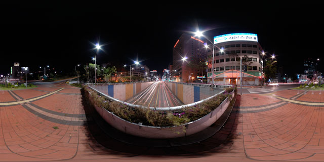
360° VR panorama of the Toegyero intersection (퇴계로2가교차로) bridge at night, in Juja-dong (주자동), Jung-gu (중구), Seoul (서울), South Korea. Across the road to the north can be seen the Seongchang Building (성창 빌딩), which houses various shops and the Outback Steakhouse Chungmuro branch (아웃백스테이크하우스 충무로점), and next to that, the Sejong Hotel (세종호텔). On the opposite side of the road, to the south-west, is the Huengkook Building (훙국빌딩), home to Kiswel Co. Ltd.
Click button below to view 360° VR interactive panorama
SD Standard definition suitable for users with slow internet connections or mobile devices or HD High definition suitable for users with fast internet connections
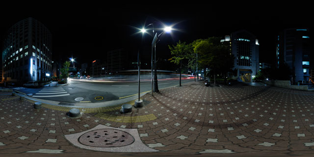
360° VR panorama of the streaks of light left by cars and buses as they travel down Samil-ro (삼일로) at night in Jeodong 2(i)-ga, Jung-gu, Seoul, South Korea. Nearby can be seen the Young Nak Presbyterian Church (영락교회) 50th Anniversary Commemorative Hall to the north, the Silver Building (은광빌딩) to the east, and the Joyang Building (조양빌딩) to the south-east.
In the distance to the south can be seen the N Seoul Tower (엔 서울타워), lit up with its evening lightshow.
Click button below to view 360° VR interactive panorama
SD Standard definition suitable for users with slow internet connections or mobile devices or HD High definition suitable for users with fast internet connections
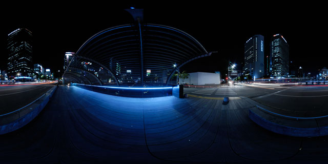
360° VR panorama of Samil Bridge (삼일교), lit along the sides by blue strip lights at night as traffic passes over the bridge, in Gwancheol-dong, Jongno-gu, Seoul, South Korea. Samil Bridge carries Samil-ro over the Cheonggye Stream, an 8.4 km long stream that runs through downtown Seoul.
To the north-west can be seen the Samil Building (삼일빌딩), also known as the 31 Building (31빌딩). Built in 1970, the Samil Building was the tallest building in Seoul until the Lotte Hotel was completed in 1979. To the south-west are the Hanwha Group Building (한화그룹빌딩) and Janggyo building (장교빌딩).
Click button below to view 360° VR interactive panorama
SD Standard definition suitable for users with slow internet connections or mobile devices or HD High definition suitable for users with fast internet connections
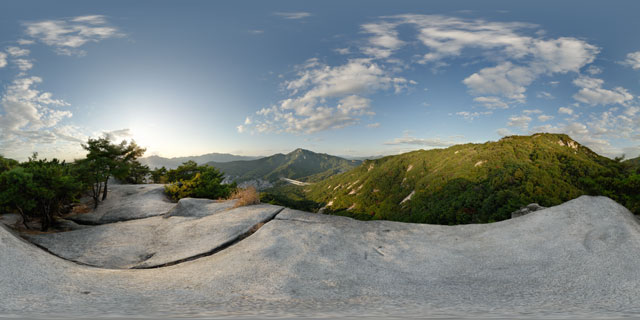
360° VR panorama from a lower peak of Mount Buram (불암산), in Sanggye-dong, Nowon-gu, Seoul, South Korea. To the north-west can be seen a small section of the Seoul Ring Expressway, where it leaves the tunnel from Buramsan and enters a tunnel through Suraksan (수락산). In the distance in the west can be seen the mountains Dobongsan (도봉산) and Bukhansan (북한산), and below can be seen parts of Nowon-gu, a north-eastern district of Seoul.
Click button below to view 360° VR interactive panorama
SD Standard definition suitable for users with slow internet connections or mobile devices or HD High definition suitable for users with fast internet connections
360° VR panorama from a minor peak on the western side of Buramsan (불암산), in Sanggye-dong, Nowon-gu, Seoul, South Korea. Part of Seoul’s urban sprawl can be seen down below, while on the peak pine trees grow out of the granite rock.
Click button below to view 360° VR interactive panorama
SD Standard definition suitable for users with slow internet connections or mobile devices or HD High definition suitable for users with fast internet connections
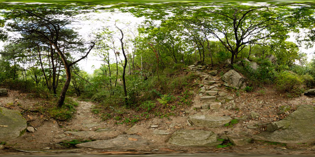
360° VR panorama of one of the paths heading up the western side of Buramsan (불암산), in Sanggye-dong, Nowon-gu, Seoul, South Korea. Much of South Korea’s landscape is mountainous, and mountain climbing is a popular passtime there, with well defined trails on most mountains.
Click button below to view 360° VR interactive panorama
SD Standard definition suitable for users with slow internet connections or mobile devices or HD High definition suitable for users with fast internet connections
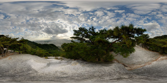
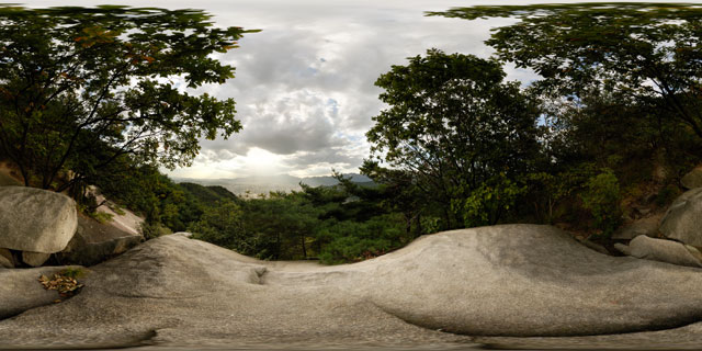
360° VR panorama from a large granite rock part way up Buramsan (불암산), in Sanggye-dong, Nowon-gu, Seoul, South Korea. In the distance to the west, the sun can be seen breaking through the clouds and shining down on part of Seoul. On the horizon are the mountains Bukhansan (북한산) and Dobongsan (도봉산).

Click button below to view 360° VR interactive panorama
SD Standard definition suitable for users with slow internet connections or mobile devices or HD High definition suitable for users with fast internet connections
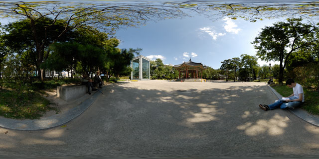
360° VR panorama of Tapgol Park (탑골공원), in Jongno-gu, Seoul, South Korea. In the centre of the park is the Palgakjeong pavilion (팔각정) where the Korean Declaration of Independence was read on March 1st 1919, when Korea was under Japanese rule. To the north of the pavilion is a large structure holding the 10 storey stone pagoda of Wongaksa temple (원각사지십층석탑).
Tapgol Park was originally the location of Wongaksa temple (원각사), until the temple was closed by King Yeonsangun, who supressed Buddhism during his reign (1494-1506). It is unknown when the park was constructed, but it is believed to have been sometime during the 1890s, and was the first modern park to be built in Seoul. Its construction was first suggested by the Irishman John McLeavy Brown, who served as Inspector General of Customs under the government of Emperor Gojong.
The park has also been known as Pagoda Park, due to the famous 10 storey stone pagoda located there, but has been known by its official name Tapgol Park since 1991.


